Past Projects
Impactful Work of the GIS Center
Explore the impactful work of the UM-Flint Geographic Information Systems Center serving our community and beyond.
Extreme Heat in Flint
The GIS Center participated in a Research and Creative Activity Fund through the Office of Research titled “A Sensor Network for monitoring Extreme Heat Events in Flint, Michigan”. Working with Dr. Marty Kaufman and two other researchers, 40 sensors were placed on bus stops throughout the City of Flint that measured temperature and humidity. This data was then mapped on a dashboard to provide information to the public and public officials.
Census 2020
The GIS Center has been funded by the Community Foundation of Greater Flint to assist them with their Census 2020 funding of nonprofits in Flint and Genesee County. The GIS Center will be mapping grantee locations and geographic areas, as well as events held by grantees for Census 2020 educational purposes. Mapping these will help make sure grantees are doing outreach in the areas needed to reach the hard to count populations.
In addition to that mapping, the GIS Center will also be collecting information associated with the census, including the creation of an index to show potential hard to count areas in the region, as well as other State of Michigan efforts. Through this funding, the GIS Center Manager will also be participating on the City of Flint Mayoral Executive Complete Count Committee, helping with mapping on other partner events and efforts.
Low Voter Turnout–Secretary of State
The Michigan Secretary of State’s office reached out to the GIS Center due to the City of Flint Community Profiles report. They were interested in finding out specific information about communities that had low voter turnout in the past four major elections (2012, 2014, 2016, 2018).
Flint has 13 precincts in the bottom 100 precincts in terms of voter turnout. So the GIS Center assisted in collecting demographic data about the 100 precincts with the lowest voter turnout, as well as aerial maps of each precinct.
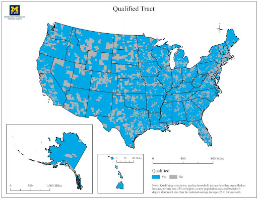
Senator Peters’ Proposed Bill Data Analysis
Senator Gary Peters of Michigan reached out to the University Outreach office and GIS Center to assist with mapping data needed for a proposed bill. The bill would assist with post-grad scholarships to pay off student debt not being taxed.
Based on set criteria, census tracts were determined to be qualified or non-qualified. Static maps and an interactive map were created for their team.
Flint Historical Spatial Data Infrastructure
The Office of the Provost hired a postdoc position examining deep-mapping of the Flint area. Using historical information such as imagery, maps, Sanborn fire maps, narratives, and other artifacts, the post-doc researcher is creating some test applications throughout a year in two neighborhoods, Civic Park and Floral Park, within the City of Flint.
The GIS Center is assisting with data collection/creation, as well as making hardware/software available to the researcher. For more information, visit flintflashproject.umich.edu.
Flint Retail Leakage and Consumer Data
Metro Community Development approached the GIS Center to create a similar report for their purposes with updated data. MCD requested for retail market analysis, in addition to select demographic variables, to be completed for 5 minute drive time areas around 13 different intersections throughout the City of Flint.
These new data provided information for their programming around small businesses in Flint.
SmartZone Feasibility
Dr. Marty Kaufman and Troy Rosencrants, GIS Center, explored the possibility for SmartZone satellites within the 7-county I-69 Thumb Region. Dr. Kaufman’s team used Geographic Information System to identify economic opportunities based on US Census data, NAICS codes and infrastructure assets.
The project team envisioned regional economic development as a function of four factors: available land; available labor; connectivity of related firms; and need. Using a Geographic Information System approach, multiple data layers were combined to create a SmartZone feasibility model.
The model used six data layers (variables) that explained the most variance in a multiple regression model. All model parameters were significant at the 0.5 level, with existing business density and available buildings exhibiting the highest coefficients. The variables were: all businesses, available buildings, available vacant land, travel time less than 30 minutes, commercial traffic density, and transport/warehouse businesses.
“Renew the Avenue” Crime Prevention
The GIS Center was the lead GIS analyst on a $1 million grant from the Department of Justice Byrne Criminal Justice Innovation Program. They collaborated with researchers from the University of Michigan-Ann Arbor, Michigan State University, and Kettering University, along with area community organizations.
The overarching goal of the project was to reduce blight and crime in the University Avenue Corridor within the City of Flint.
City of Flint Lead Service Line Mapping
The GIS Center approached the City of Flint in October 2015 to provide any support in the Flint Water Crisis that we could. After receiving images of the city showing the curb boxes, the GIS Center hired 8 assistants and with the help of Troy Rosencrants, coded more than 56,000 parcels within the City with the type of service line connections at each parcel.
In total, the process took about three weeks. The GIS Center provided the data to Mayor Weaver and the City of Flint on February 12, 2016 and participated in a press conference on February 22, 2016 to announce our findings.
Using GIS to Characterize Risks of Hazardous Materials
The GIS Center was a part of a UM-Flint Research and Creativity Fund grant. Two primary objectives of this project are:
- To ascertain through water sampling whether a spatial correlation exists between the presence of stored hazardous materials and the water sampled at drainage outfalls
- To spatially assess an area’s fire-fighting capability given the potential fire risks
These analyses focused on two communities within Genesee County, Michigan: Grand Blanc City and Flint Township. A key outcome from this study was the synthesis of storm-sewer sheds through the use of LIDAR data, storm sewer outfalls and storm drain locations.
The project participants were the GISC, Genesee County GIS Office and the Genesee County Dept. of Emergency Management and Homeland Security; Grand Blanc Dept. of Public Works and Fire Department, and the Flint Township Fire Department. Dr. Marty Kaufman from Earth and Resource Science is the lead investigator, with Troy Rosencrants from the GISC and Tayseer Wasif from Chemistry/Biochemistry acting as co-investigators.
From this research, Dr. Marty Kaufman and Troy Rosencrants published a scholarly article discussing the fire-flow capacity analysis to the Fire Safety Journal.
Building Neighborhood Capacity Program
Metro Community Development asked the GIS Center to create a map of the Building Neighborhood Capacity Program wards in northern Flint for their executive summary of the report. The map included schools, churches, housing, bus routes, bike routes, and parks along with BNCP landmarks.
Crim Fitness Foundation Safe Routes to School Mapping
CRIM Fitness Foundation requested the GIS Center to create a series of maps for their grant application to Safe Routes to School. The maps show the location of students along with two buffered areas to determine the number of students within a 2 mile radius of the school.
The first buffer shows straight line distance from the school and the second buffer shows 2 miles along roads from the school.
University of Michigan-Flint Mapping for Faculty/Staff
The GIS Center has assisted many faculty and staff with project mapping, figure creation, classwork, etc. Below are some of the projects:
- Government & Community Relations – Mapping of events and fundraising projects
- Alumni Relations – Mapping of alumni locations for visit planning
- Dr. Victoria Morckel, Geography, Planning, and Environment – Variety of figures for publication
- Dr. Jacob Lederman, Sociology – Figures for publication in journal and books as well as data assistance
- Dr. Beverly Smith, Anthropology – Figure creation
- Educational Opportunity Initiatives – Map creation for programming
- Career Center – Map creation for results of First Destination Survey
- Dr. Michelle Sahli, Public Health – GIS assistance with student project
- Dr. Emily Feuerherm, English – Assistance with GIS mapping for ESL projects
- Dr. Lisa Lapeyrouse, Public Health – GIS assistance with student intern project
- Dr. Rie Suzuki, Public Health – GIS assistance with student projects and research
- Dr. Thomas Henthorn, History – GIS assistance, helped with class workshop on mapping in Historical Preservation
Student Assistant Past Projects
- City of Flint Profiles – Matthew McCloskey
- As part of UROP, Matt McCloskey assisted in the GIS work for a report as a part of the MapFlint project. The report was titled “City of Flint Community Profiles by Ward” and can be found at the MapFlint website.
- Student Mobility – Melissa Hertlein
- As part of UROP, Melissa Hertlein assisted in the GIS work for a report as a part of the MapFlint project. The report was titled “Student Mobility in the Flint Community School District” and can be found at the MapFlint website.
- Smartzone Feasibility Kristin Bell And Mike Keller
- Kristin Bell and Mike Keller helped the GIS Center by performing data collection and GIS analysis on a grant titled “SmartZone Feasibility” funded by UM-Flint’s EDA University Center for the Summer of 2017.
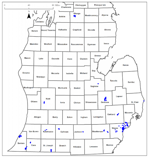
- Selecting Study Sites In The Investigation Of The American Marten In Northern Michigan Jeff Bellinger
- Jeff Bellinger assisted Dr. Jill Witt, Biology, by performing the GIS analysis to help select study sites to examine the DNA characteristics and distribution of the American marten in the northern portion of the Lower Peninsula of Michigan.
- Areal Analysis Of Crime Risk In Flint, Mi – Alex Maguffee
Office of Research and Sponsored Programs funded project that addressed the needs of law enforcement agencies to objectively quantify neighborhood level data as it relates to crime risk exposure variables.